Welcome to the Tucson Bird Count

Where Birds Thrive, People Prosper
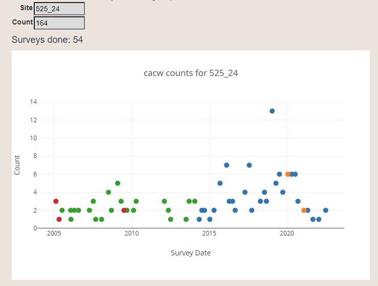
Check out our new data-viewing features! You can choose a bird species and see where in the study area they have been detected. Click on one of those points and see how the detections have changed over time with an auto generated graph and corresponding table. See this data analysis feature here or click the image below of a sample graph.

Welcome to the Tucson Bird Count website! Data entry, resources for surveyor and summaries are located under the Results and Data Entry Tab.

Welcome to the Tucson Bird Count!
Where Birds Thrive, People Prosper
The Tucson Bird Count is dedicated to making Tucson a better place for birds and for all of us
The Tucson Bird Count aims to help people make informed decisions regarding the impacts of human actions on wildlife. Urbanization is a movement that is well established and will continue to grow in the future and one way to reconcile that loss of habitat is to endeavor to share our urban space with native birds and wildlife. Through informed decisions we can all help Tucson sustain a diverse bird community which is good for the birds and also enhances the quality of life for Tucson’s human inhabitants.
The Tucson Bird Count is a citizen-science driven effort that has documented how native birds use the habitat within and surrounding Tucson for over a decade. The information gained through this study has allowed informed recommendations on what Tucsonans can do within their yards, neighborhoods and communities to make Tucson a better place for birds. As Tucsonans make changes and efforts to share their city space with native birds, the count effort itself will document how birds respond to all of our efforts to provide habitat for native birds right within our own habitat.
Whether you are helping with the volunteer annual bird counting efforts or enhancing your urban habitat for the benefit of native birds, you are helping make Tucson a better place for birds and for all of us. Thank you.
2023 Tucson Bird Count
Available Routes
These are the routes that are currently available and in need of a counter. Each route is a series of multiple points and each route is a different color. Please email Jennie at jmacfarland@tucsonaudubon.org to claim a route. I am doing my best to keep this map current and routes are first come, first served.
List of Spring Routes Available in 2023 – Counted Once a Year
| RouteID | Name |
| 103 | Central North – Kolb from River to Sunrise |
| 111 | North West – Oracle from River to Magee |
| 112 | North West – Oracle from Ina to Hardy |
| 113 | North West – Oracle from River to Hardy |
| 116 | North West – Ina from Silverbell to La Cholla |
| 117 | North West – I-10 from Ruthrauff to Orange Grove |
| 119 | North West – Silverbell and Sunset, west of I-10 |
| 120 | North West – West of Silverbell at Orange Grove, inlcudes some desert locations |
| 121 | North West – Sunset and Gerhart |
| 123 | Central West – West of Silverbell around Sweetwater Drive |
| 126 | Central West – Speedway west into Tucson Mountain Park |
| 129 | Central West – I-10 from Speedway to Wetmore |
| 132 | Central West – From Starr Pass and Greasewood to Grant and 1st St. |
|
133 135 |
South West – I-19 conection with I-10 north to Congress South West – Ajo and Kinney Rd. |
| 136 | South West – Ajo and Mission Rd near Kennedy Park |
| 138 | South West – I-19 from Valencia to Ajo |
| 140 | Central South – Campbell from Valencia to Benson Hwy |
| 141 | Central South – west of Alvernon from Valenica to Silverlake |
| 142 | Central South – west of Alvernon from Valencia to 36th St. |
| 143 | Central South – Valencia and Alvernon |
| 144 | Central South – north of Valencia and east of Alvernon |
| 149 | North East – Houghton and Catalina Highway |
| 155 | Central East – Golflinks from Wilmot to Houghton |
| 156 | North East – Houghton from Tanque Verde Rd. to Snyder Rd. |
| 157 | Central East – Harrison from 22nd to Wrightstown |
| 162 | North East – north of Reddington, east of Soldier Trail |
| 164 | Central East – Broadway from Harrison to Freeman into Saguaro NP East |
| 168 | Central East – Houghton and Drexel |
| 169 | South East – Houghton and Invington |
| 170 | North West – Oracle and Ina |
| 172 | North West – Oracle and Lambert |
| 175 | North West – Cortaro Farms Rd west of I-10 |
| 176 | North West – Cortaro and Silverbell |
| 179 | Marana – Silverbell and Twin Peaks |
| 180 | Oro Valley – Thornydale and Lambert |
| 185 | South West – Ajo east of Kinney Rd. |
List of Park Routes Available in 2024 – Counted Four Times a Year
| 507 | Arroyo Chico Wash, Tucson to Randolph |
| 510 | Arthur Pack Regional Park |
| 516 | Fred Enke Wash |
| 524 | Tanque Verde Wash |
| 530 | Tucson Mountain Park |
| 541 | Pima Canyon Estates |
| 538 | Barrio Kroeger Lane Neighborhood |
| 544 | Big Wash/OVMP |
| 548 | Avra Valley WWTP |
| 552 | Michael Perry Park |
| 922 | Saguaro NP East: South Route |
| 943 | Sabino Canyon – Bear Canyon |
| 943 | Sabino Canyon – Bear Canyon |